
High Performance Aviation
Innovation Procrastination?
In the age of rapidly changing technology it is nearly impossible to keep up with the latest computer, tablet, or smart phone. Aviation is beginning to see similar technological innovation at a pace unmatched in any previous period of history. It’s amazing that until the past decade or so, our IFR system depended heavily on outdated and archaic systems of navigation
Did you know that some of the navigation technology in our modern planes has been around for over 80 years? NDBs (non-directional beacons) were first used in the 1930’s. While very simplistic, NDBs were an early step in building a foundation for IFR navigation. However, there were also limitations that spurred the need for more advanced navigation equipment, such as VORs in the 1950s and 1960s (very-high frequency omni range), which allowed for selection of specific radials, and a more complex and accurate IFR system.
Later came LORAN (Long Range Navigation) and RNAV (area navigation) which promised great capability of point to point navigation which meant no longer wasting time flying indirect routing to stay on the designated airways.
GPS (global-positioning system) was next and simplified point-to-point navigation and improved accuracy while relying only on satellites for the position calculation.
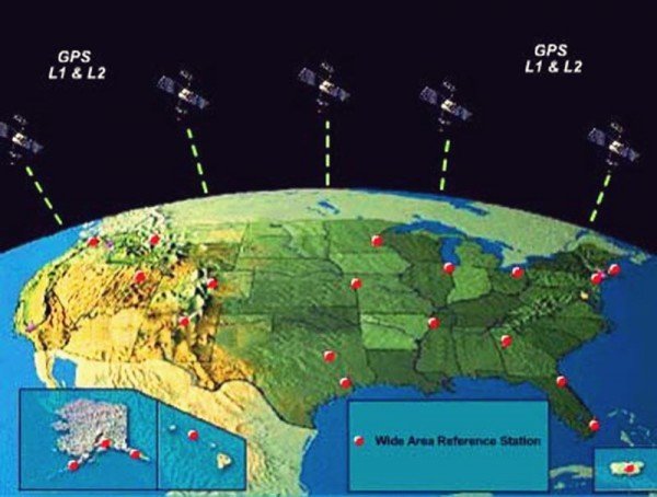
Now let’s talk about the latest and greatest innovation, WAAS – Wide Area Augmentation System. WAAS is basically GPS on steroids. It takes the existing infrastructure of the GPS satellite constellation and also uses a limited number of ground-based stations called wide area reference stations to improve the sensitivity of the position calculation. WAAS improves accuracy in both the lateral and vertical directions, allowing us to now fly GPS approaches which feature angular course guidance (similar to a localizer), and a glidepath (similar to a glideslope). Approaches with LPV minimums often have decision heights as low as 200 or 250 ft. AGL.
Before you start to criticize this young whippersnapper who is eager to adopt new technology, I’ve already heard all the horror stories and conspiracy theories about “the day the government decides to shut down GPS”. Yes, the US Department of Defense does control the GPS satellite constellation, and for a period of time they downgraded the GPS sensitivity to limit accuracy to an acceptable level for security concerns. This intentional degradation was called “selective availability” and was discontinued in May of 2000. Future satellites known as GPS III will not support this ability, so rest assured that GPS is here to stay.
What are the Benefits of WAAS?
- RNAV/GPS Approaches with Vertical Guidance, many of which are just as good or close to ILS minimums
- Lower minimums than traditional GPS approaches (LPV, LNAV/VNAV, or LP minimums)
- More approaches at smaller airports
- Encourages flying a “stabilized approach” rather than “dive and drive”
- Improved safety during the approach phase of flight even in VFR conditions
How Does WAAS Work?
(Image source: www.faa.gov)
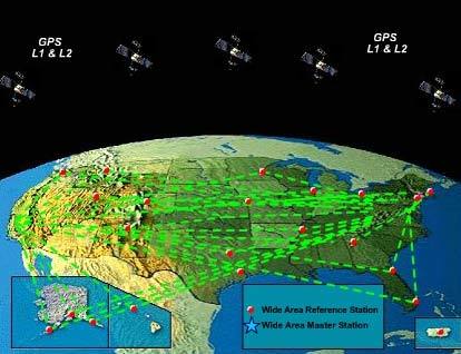
- GPS information is gathered by wide area reference stations (WRS). These stations are placed in precise locations where any necessary signal adjustments can be calculated.

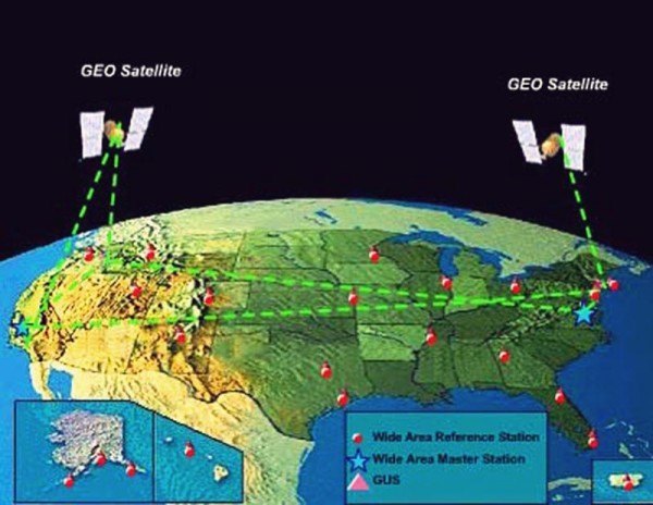
- This information is relayed to the WAAS Master Station (WMS).

- The augmentation messages are then sent from the WMS to the ground uplink stations to be transmitted to the geostationary satellites. The geostationary satellites stay above the US to support our country’s WAAS system.

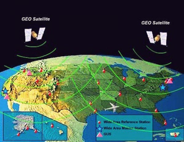
- The corrected signals from the geostationary satellites get passed down to the end users to improve the accuracy and sensitivity of the GPS-calculated position. These geostationary satellite signals can also be used by the WAAS receiver as an additional source for calculation of the user’s position.

On an interesting side note: Other countries have their own WAAS-like systems, like EGNOS (European Geostationary Navigation Overlay Service) and MSAS (Multi-functional Satellite Augmentation System) that serve the same purpose. These are all considered types of satellite-based augmentation systems (SBAS).
What if I Lose WAAS?
The key term for GPS users prior to WAAS was RAIM – Receiver Autonomous Integrity Monitoring. We could check RAIM availability at any location to check for adequate signal coverage at a desired location. WAAS, on the other hand, features built-in integrity monitoring capabilities. WAAS systems have been designed to strict safety standards and will warn users within six seconds of any faulty information that could cause errors in the GPS position estimate. (This would be extremely rare in most parts of the US).
Summary
WAAS adds greater capability to general aviation aircraft offering safety and precise vertical guidance. LPV approaches now outnumber ILS approaches within the US. It is cost-effective, accurate, and provides the basis for the future of aviation navigation. Over the past decade, WAAS has grown significantly in popularity and is now standard in most new aircraft. Many GPS receivers can be upgraded or replaced to provide WAAS in any model of aircraft. If you have not yet upgraded, you may want to consider the benefits of adding WAAS to your airplane.
Would you like more information?
Send us a message below.

MEET HPA
FOLLOW US