
High Performance Aviation
Garmin GPSMap 496 – Keep it Simple!
by Brendan Boyd (Gold Seal CFI/CFII/MEI/AGI, CSIP)
Sometimes the best things in life are the simplest. In a day and age where our cockpits are so full of avionics, moving maps, radio chatter, bright lights, countless buttons, switches, circuit breakers, radar, iPads, charts… it’s easy to be dazed by a sense of information overload. It is in these situations I find the tool with the least to think about can be the most helpful. I present to you the Garmin GPSMap 496.’
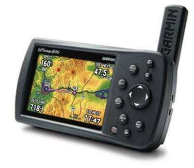
Some of you out there may have crossed paths with the GPSMap 496. A small, portable GPS unit, Garmin touts the device as “the world’s most highly evolved aviation portable[s].” I’m inclined to agree. It is not often you can claim a GPS is evolved on one hand, and easy-to-use on the other. The 496 fits snuggly into that category, almost as if it invented the concepts of functionality and simplicity. Wonderfully designed, the 3.8” color screen adds immeasurably to the pilot’s situational awareness, contributing to the overall success and safety of flight. And with 10 minutes and a little know-how, you can all but master this powerful device.
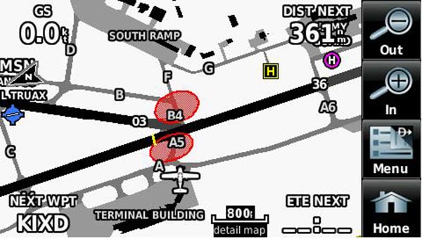
Those who have flown a G1000-equipped airplane may be familiar with Garmin SafeTaxi®. In my aviation career, the first place I ever used SafeTaxi® was in a technically-advanced aircraft. However, the GPSMap 496 is right on pace with his G1000 brother. Out of the box, the 496 comes preloaded with Garmin’s SafeTaxi® data! This simple unit can be the difference between requesting a progressive taxi and navigating the pavement as if you know the airport like the back of your hand. In the worst possible scenario, the real-time taxiway diagram could prevent an inadvertent entry onto a runway, in an unfortunate situation known as a runway incursion.
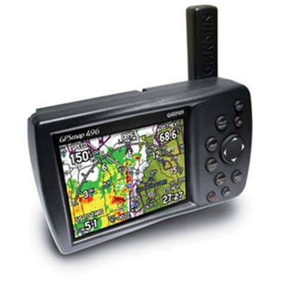
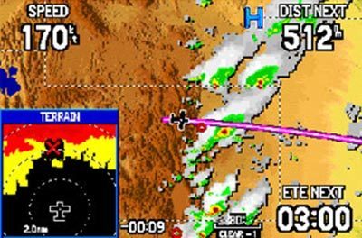
In flight, the device is just as nimble and useful. Though not certified for IFR flight, a wealth of information is still provided that can enhance situational awareness. During VFR flight, the GPS helps navigate near airspaces, including an altitude proximity feature that easily warns the pilot of proximity to Class B airspace. With a valid XM subscription, it will provide the same NEXRAD information that you might find on an Avidyne MFD or G1000. Also provided are METARs, TAFs, TFRs, Lightning, Winds Aloft, and even Satellite Radio! The unit is even capable of Traffic Information System alerts when coupled with a Mode S Transponder. With a valid Jeppesen database, terrain information and nearest waypoint options are easily displayed. That’s right, the unit that appears inferior to many other avionics suites available flaunts many of the same features. Looks can be deceiving, friends, so don’t let size fool you!
Now, I know you’re all asking yourselves, “Where can I get one of these fantastic little machines?” Sadly, Garmin is no longer producing this particular product, but don’t be discouraged! Many units are available throughout the aviation community. Places like your local avionics shop or FBO may know individuals looking to sell, and I’m sure one can find almost anything on eBay! Garmin still provides support for the GPSMap 496, so if you are lucky enough to get your eager hands on one, product support is readily available. And in the cockpits of today, you may be half tempted to simply shut off the battery masters, pull out your 496, and KISS (Keep it simple, silly)!
Would you like more information?
Send us a message below.

MEET HPA
FOLLOW US